


BINGO!

Wolf Park is celebrating its 52nd Birthday.
Monticello
DELPHI — The legal team for accused Delphi murder suspect Richard Allen is asking the public for help in paying for the cost of defense experts in Allen’s upcoming jury trial.

Andrew Johnson sent in these photos of American pelicans.
Smiles of the Day
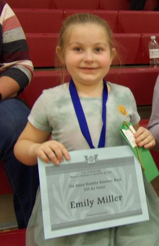
Emily Miller is smiling because she received an art award for Disability Awareness Month Thursday night.


Monticello, IN
Right Now
- Humidity: 32%
- Feels Like: 55°
- Heat Index: 58°
- Wind: 13 mph
- Wind Chill: 55°
- UV Index: 0 Low
- Sunrise: 07:01:25 AM
- Sunset: 08:31:10 PM
- Dew Point: 28°
- Visibility: 10 mi
Today
Cloudy skies this evening will become partly cloudy after midnight. Low 36F. Winds WNW at 10 to 20 mph.
Tonight
Cloudy skies this evening will become partly cloudy after midnight. Low 36F. Winds WNW at 10 to 20 mph.
Tomorrow
Sunny, along with a few afternoon clouds. Cool. High 51F. Winds WNW at 10 to 20 mph.
Chance of Rain: 2%
Sunrise: 07:01:25 AM
Sunset: 08:31:10 PM
Humidity: 49%
Wind: WNW @ 13 mph
UV Index: 0 Low
Friday Night
Cloudy skies this evening will become partly cloudy after midnight. Low 36F. Winds WNW at 10 to 20 mph.
Chance of Rain: 1%
Sunrise: 06:59:57 AM
Sunset: 08:32:13 PM
Humidity: 46%
Wind: WNW @ 14 mph
UV Index: 7 High
Saturday Night
Partly cloudy. Low 34F. Winds NW at 10 to 15 mph.
Chance of Rain: 4%
Sunrise: 06:58:28 AM
Sunset: 08:33:16 PM
Humidity: 47%
Wind: WNW @ 10 mph
UV Index: 7 High
Sunday Night
Clear skies. Low 37F. Winds W at 5 to 10 mph.
Chance of Rain: 4%
Sunrise: 06:57:01 AM
Sunset: 08:34:20 PM
Humidity: 44%
Wind: SW @ 11 mph
UV Index: 7 High
Monday Night
Cloudy skies. Low 47F. Winds SSW at 10 to 15 mph.
Chance of Rain: 66%
Sunrise: 06:55:35 AM
Sunset: 08:35:23 PM
Humidity: 54%
Wind: SW @ 18 mph
UV Index: 3 Moderate
Tuesday Night
Showers in the evening, then partly cloudy overnight. Low 39F. Winds WNW at 10 to 20 mph. Chance of rain 60%.
Chance of Rain: 9%
Sunrise: 06:54:10 AM
Sunset: 08:36:26 PM
Humidity: 59%
Wind: NNW @ 12 mph
UV Index: 7 High
Wednesday Night
Mostly clear skies. Low 34F. Winds NNE at 10 to 15 mph.
Chance of Rain: 6%
Sunrise: 06:52:46 AM
Sunset: 08:37:30 PM
Humidity: 56%
Wind: E @ 6 mph
UV Index: 7 High
Thursday Night
Partly to mostly cloudy. Low 44F. Winds ESE at 5 to 10 mph.
Recent Obituaries
Special Sections Spotlight


Twin Lakes High School’s Jamison Ousley signed his National Letter of Intent on April 11 to continue his athletic career next season at the University of Evansville where he will golf collegiately.

While Frontier’s varsity baseball team will have a new head coach at the helm in Ron Benakovich, they too will have new faces on the diamond as they tout a roster made up of 13 underclassmen.

As they continue to get deeper into the regular season, Twin Lakes’ varsity softball team is finding new ways to push the envelope of growth while still looking to accumulate wins along the way.

With a new roster along with a new coach at the helm, the overall makeup of Frontier’s varsity softball team may have a different look but the goals remain the same.

Business

What’s better than a 100 GRAND candy bar? Alliance Bank donating over $100,000 to local non-profits in 2023. Alliance Bank is celebrating the milestone this month by handing out fun size 100 G…

In celebration of Ag Week, Alliance Bank is highlighting the stories of farmers in our community.

The estimated monthly mortgage payment for a median-priced U.S. home is about 54% higher today than it was just two years ago. These are the states and metros who have been most impacted by high interest rates.
This tax season, millions of Americans have sent in payments to a poorly managed organization that spends trillions more than it receives in revenue. Absurdly, its customers will continue receiving a poor product that causes more problems than it solves. If our federal government was run like a business, these results would be unacceptable and the leaders would be fired.

Tornadoes have impacted all U.S. states during the last decade, save for Alaska, causing $14.1 billion in damages. Half of that damage occurred in just five states: Alabama, Arkansas, Illinois, Mississippi, and Texas, demonstrating the pronounced shift eastward from Tornado Alley to “Dixie Alley”—the area roughly stretching from eastern Texas to the western borders of the Carolinas. It also underscores the growing evidence that global warming is making extreme weather events more frequent or more intense. To find the locations seeing the biggest increase in tornadoes, researchers ranked locations by the total change in high-intensity tornado occurrences from the 20-year period ending in November 2004 to the 20-year period ending in November 2023.
History's Mysteries

The three-year span from 1903 to 1906 identifies the groundwork period, building and completion of Monticello’s Carnegie Library.

If you have followed this column over the last year, you will remember the article on Burnettsville’s newspapers. Today we will share “the rest of the story.”

The March 29, 1918, edition of the White County Democrat featured an article about State Fire Marshal McCall’s condemnation and removal of nine Monticello structures.